Recap & Regard3D for Reality Capture and 3D scanning
AulaGEO Academy,Golgi Alvarez
1:11:34
Description
Create, clean and export 3D models and pointcloud files using Autodesk Recap and open software model
What You'll Learn?
- Crate 3d model from images
- create point cloud model from images
- clean point cloud model
- manage modelos with Regard3D, ContextCapture, AutoDesk Recap and Civil3D
- Export modelos to show and sale in Internet
- Bring from AutoDesk Recap to Civil3D
- Share the model to Internet
Who is this for?
What You Need to Know?
More details
DescriptionIn this course you will learn to create and interact with digital models.
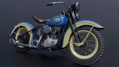
-Creating 3D models using images, such as the technique of photogrammetry with drones.
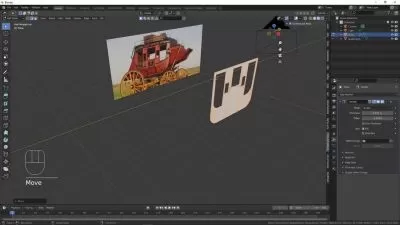
-Use free software, Regard3D and MeshLAb
-Make it using AutoDesk Recap,
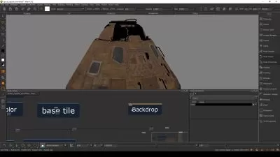
-Make it using Bentley ContextCapture,
-Generate point clouds
-Create surface in Civi3D from point cloud
-Clean, thematize and export point cloud model,
-Share the model to Internet using SketchFab
And above all, with the same model. #AulaGEO
Includes materials and examples to replicate practices.
Crate 3d model from images
create point cloud model from images
clean point cloud model
manage modelos with Regard3D, ContextCapture, AutoDesk Recap and Civil3D
Content:
Create digital models with open source software
Lecture 1: Create digital models with Regard 3d
Lecture 2: Clean point cloud with Meshlab
Create digital models with AutoDesk Recap
Lecture 3: Creating the 3D from images
Lecture 4: Cleaning the model
Lecture 5: Visualize, correct errors and align the model
Interaction with AutoDesk Civil3D
Lecture 6: Import point cloud and create surface in AutoDesk Civil 3D
Create model with Bentley ContextCapture
Lecture 7: Create digital model from images with Bentley ContextCapture
Creation of digital model with AutoDesk Recap
Lecture 8: Select images and Create the project
Lecture 9: Download the project and visualize the project
Lecture 10: Clean and trim the model
Lecture 11: Display the model
Lecture 12: Open, thematize and export point cloud with Recap
Lecture 13: Publish model on the internet
Who this course is for:
- Engineers, Architects, GIS and geomatic enthusiasts
In this course you will learn to create and interact with digital models.
-Creating 3D models using images, such as the technique of photogrammetry with drones.
-Use free software, Regard3D and MeshLAb
-Make it using AutoDesk Recap,
-Make it using Bentley ContextCapture,
-Generate point clouds
-Create surface in Civi3D from point cloud
-Clean, thematize and export point cloud model,
-Share the model to Internet using SketchFab
And above all, with the same model. #AulaGEO
Includes materials and examples to replicate practices.
Crate 3d model from images
create point cloud model from images
clean point cloud model
manage modelos with Regard3D, ContextCapture, AutoDesk Recap and Civil3D
Content:
Create digital models with open source software
Lecture 1: Create digital models with Regard 3d
Lecture 2: Clean point cloud with Meshlab
Create digital models with AutoDesk Recap
Lecture 3: Creating the 3D from images
Lecture 4: Cleaning the model
Lecture 5: Visualize, correct errors and align the model
Interaction with AutoDesk Civil3D
Lecture 6: Import point cloud and create surface in AutoDesk Civil 3D
Create model with Bentley ContextCapture
Lecture 7: Create digital model from images with Bentley ContextCapture
Creation of digital model with AutoDesk Recap
Lecture 8: Select images and Create the project
Lecture 9: Download the project and visualize the project
Lecture 10: Clean and trim the model
Lecture 11: Display the model
Lecture 12: Open, thematize and export point cloud with Recap
Lecture 13: Publish model on the internet
Who this course is for:
- Engineers, Architects, GIS and geomatic enthusiasts
User Reviews
Rating
AulaGEO Academy
Instructor's Courses
Golgi Alvarez
Instructor's Courses
Udemy
View courses Udemy- language english
- Training sessions 14
- duration 1:11:34
- English subtitles has
- Release Date 2024/05/08