QGIS - Geographic Information Systems
AulaGEO Academy,Golgi Alvarez
2:41:11
Description
Learn to use QGIS through practical exercises
What You'll Learn?
- Learn QGIS from zero
- Create, import data, analyze and generate final maps
- Learn doing, through step by step use cases - All in the same environment of data.
Who is this for?
What You Need to Know?
More details
DescriptionCourse Definition:
Disclaimer
This course originally was built in spanish, following the same lessons done in the popular course Learn ArcGIS Pro Easy! We done it to demostrate than all this could be possible using open software; always in spanish.  Then, some english users asked us, we created a english version of the course; it´s the reason why the interface of the software is in spanish.
---------------------------------------------------------------- #AulaGEO
Geographic Information Systems using QGIS.
-All the exercises you can do in ArcGIS Pro, made with open source software.
-Import data from CAD to GIS
-Attribute-based thematization
- Rules-based calculations
-Layout print
-Import coordinates from Excel
- Digitalization tricks
-Geoeferencing images
All available files so you can put the acquired knowledge into practice.
Done by an expert, spoken aloud, in a single work environment to learn gradually using the AulaGEO methodology
In the Georeferencing images class you will be able to visualize the ease of placing points in this free system, georeferencing raster images.
What will the user learn?
-All the exercises that you can do in ArcGIS Pro are done with free software.
-It will import data from CAD to GIS
-Theming based on attributes
-Rule-based calculations
-Layout printing
-Import coordinates from Excel
-Digitization tricks
-Georeference images
The classes you will see include the following topics:
Section 1
Class 1: Let's start with QGIS
Class 2: Data selection
Class 3: Bookmarks - bookmarks
Section 2
Class 4: XY from Excel
Lecture 5: Data symbology
Lecture 6: Editing attribute data
Class 7: Labeling of attributes
Class 8: Digitization of geographic information
Class 9: Georeference images
Analysis of data
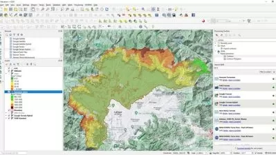
Lecture 10: Influence Analysis - Buffer
Publish content with QGIS
Class 11: Generation of maps
Let's do it at AulaGEO - step-by-step exercises
Exercise 1. Import CAD data to GIS
Exercise 2. Import coordinates from Excel to divide a polygon
Exercise 3. Calculation of areas and composition of calculated fields
Exercise 4. Buffer Analysis
Exercise 5. Attribute labeling
Exercise 6. Theming by attributes
Exercise 7. Digitization tips
Exercise 8. Georeferencing images
Who this course is for:
- Everyone who wants to improve their profile and expand their opportunities in geospatial design and analysis.
- GIS users which have used ArcGIS and want to learn how to do the process with QGIS
Course Definition:
Disclaimer
This course originally was built in spanish, following the same lessons done in the popular course Learn ArcGIS Pro Easy! We done it to demostrate than all this could be possible using open software; always in spanish.  Then, some english users asked us, we created a english version of the course; it´s the reason why the interface of the software is in spanish.
---------------------------------------------------------------- #AulaGEO
Geographic Information Systems using QGIS.
-All the exercises you can do in ArcGIS Pro, made with open source software.
-Import data from CAD to GIS
-Attribute-based thematization
- Rules-based calculations
-Layout print
-Import coordinates from Excel
- Digitalization tricks
-Geoeferencing images
All available files so you can put the acquired knowledge into practice.
Done by an expert, spoken aloud, in a single work environment to learn gradually using the AulaGEO methodology
In the Georeferencing images class you will be able to visualize the ease of placing points in this free system, georeferencing raster images.
What will the user learn?
-All the exercises that you can do in ArcGIS Pro are done with free software.
-It will import data from CAD to GIS
-Theming based on attributes
-Rule-based calculations
-Layout printing
-Import coordinates from Excel
-Digitization tricks
-Georeference images
The classes you will see include the following topics:
Section 1
Class 1: Let's start with QGIS
Class 2: Data selection
Class 3: Bookmarks - bookmarks
Section 2
Class 4: XY from Excel
Lecture 5: Data symbology
Lecture 6: Editing attribute data
Class 7: Labeling of attributes
Class 8: Digitization of geographic information
Class 9: Georeference images
Analysis of data
Lecture 10: Influence Analysis - Buffer
Publish content with QGIS
Class 11: Generation of maps
Let's do it at AulaGEO - step-by-step exercises
Exercise 1. Import CAD data to GIS
Exercise 2. Import coordinates from Excel to divide a polygon
Exercise 3. Calculation of areas and composition of calculated fields
Exercise 4. Buffer Analysis
Exercise 5. Attribute labeling
Exercise 6. Theming by attributes
Exercise 7. Digitization tips
Exercise 8. Georeferencing images
Who this course is for:
- Everyone who wants to improve their profile and expand their opportunities in geospatial design and analysis.
- GIS users which have used ArcGIS and want to learn how to do the process with QGIS
User Reviews
Rating
AulaGEO Academy
Instructor's Courses
Golgi Alvarez
Instructor's Courses
Udemy
View courses Udemy- language english
- Training sessions 23
- duration 2:41:11
- Release Date 2022/11/17