QGIS Basics: Essential Skills for Beginners
Sneha Syamprasad
4:17:14
Description
Master the Fundamentals of QGIS and Unleash the Power of Geospatial Data
What You'll Learn?
- How to download and install QGIS software
- How to navigate the QGIS interface.
- You will have a greater clarity of basic spatial data model and types of data model
- Process raster and vector data in QGIS
- You will learn in detail Map Projection and its types
Who is this for?
What You Need to Know?
More details
DescriptionAre you new to the world of Geographic Information Systems (GIS) and eager to learn the fundamentals of QGIS? Look no further! The "QGIS Basics: Essential Skills for Beginners" course is designed to equip you with the essential skills needed to navigate and utilize QGIS effectively. Whether you're a student, a professional, or simply someone interested in spatial data analysis, this course will empower you to harness the power of QGIS and unleash your geospatial potential.
In this comprehensive course, we'll cover a wide range of topics, starting with an introduction to the course in Session 1. You'll gain a clear understanding of the course objectives and get a sneak peek into what lies ahead.
Session 2 will focus on getting acquainted with the interface of QGIS. We'll explore the basic layout and components of QGIS, ensuring you feel comfortable navigating through the software. By the end of this session, you'll be familiar with the various tools and features that QGIS offers.
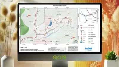
Moving on to Session 3, we'll dive into the exciting world of creating maps. You'll learn the step-by-step process of creating visually appealing maps using QGIS. From downloading data to setting up the map view and adding multiple maps, you'll gain the skills necessary to craft captivating maps for your projects. We'll also explore advanced features such as grids, rectangles, and adding essential elements like the North Arrow, Scale Bar, and Title.
Session 4 will introduce you to working with attributes in QGIS. You'll learn how to manage and analyze attribute data effectively, including selecting features by expression and exporting data in GeoJSON format. With these skills, you'll be able to extract valuable insights from your spatial datasets.
In Session 5, we'll tackle the task of importing TSV files into QGIS. You'll discover how to import spreadsheets and leverage their data within your GIS projects. This skill will allow you to incorporate external data sources seamlessly.
Next, in Session 6, we'll explore vector data styling and analysis. You'll learn various techniques to enhance the visual representation of your vector data, including color changes using expressions, categorized layer styling, and rule-based layer styling. This session will enable you to create compelling visualizations and perform essential analysis tasks with vector data.
Session 7 focuses on calculating line length and statistics, essential tasks for geospatial analysis. You'll learn how to measure the length of lines, filter data using the Query Builder, and calculate statistical metrics. These skills are crucial for data exploration and decision-making.
In Session 8, we'll delve into the world of raster data styling and analysis. You'll gain an understanding of raster data and learn techniques to style and visualize raster datasets. We'll cover topics such as loading raster data, using the Raster Calculator, and applying layer styles manually. By the end of this session, you'll be able to unlock the potential of raster data for your projects.
Session 9 introduces raster mosaicing and clipping. You'll learn how to merge and render raster data, creating stunning visual representations. Additionally, we'll cover techniques for clipping raster data using mask layers, allowing you to focus on specific areas of interest within your datasets.
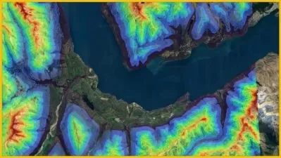
In Session 10, we'll embark on an exciting journey into terrain analysis. You'll learn how to work with terrain data, perform hillshade analysis, generate contours, and even export shapefiles for visualization in Google Earth Pro. This session will equip you with the tools necessary to analyze and understand terrain characteristics.
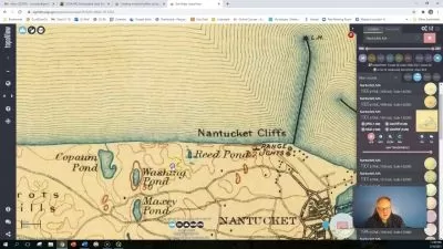
Session 11 focuses on georeferencing and map projection, two essential aspects of spatial data. You'll learn how to georeference scanned topographic maps and work with different map projections. We'll also explore the process of georeferencing aerial imagery, enabling you to align it with other spatial data layers accurately.
In Session 12, we'll tackle the process of digitizing maps. You'll learn how to add raster images, utilize image pyramids for performance improvement, and digitize point, line, and polygon features. This skill will empower you to create accurate vector data from existing maps or imagery.
Lastly, in Session 13, we'll dive into the world of OpenStreetMap data. You'll discover the QuickOSM plugin and learn how to install and use it within QGIS. We'll explore searching and downloading OpenStreetMap data, as well as layer styling techniques to enhance its visualization within QGIS.
By the end of this course, you'll have acquired essential skills in QGIS that will enable you to confidently handle geospatial data, create captivating maps, perform advanced analysis, and unlock the immense potential of QGIS for your projects. So, join us on this exciting journey and become a QGIS expert today!
Course Content:
- Session 1: Introduction to the course
- Session 2: Getting Acquainted With the Interface of QGIS
- Session 3: Create a Map
- Session 4: Working with Attributes
- Session 5: Importing TSV files in QGIS
- Session 6: Vector Data Styling and Analysis
- Session 7: Calculate the Line Length and Statistics
- Session 8: Raster Data Styling and Analysis
- Session 9: Raster Mosaicing and Clipping
- Session 10: Explore Terrain Analysis
- Session 11: Georeference and Map Projection
- Session 12: Digitizing Maps
- Session 13: Searching and Downloading OpenStreetMap Data
Who this course is for:
- GIS Students
- GIS Analyst
- Spatial analyst
- GIS engineers
- Geologists
- Geologists
- GIS Trainer
- Faculty from Engineering College
- Faculty from Bachelor Degrees
- Research Scholar
- Anyone can restart their career in Geospatial Technology
Are you new to the world of Geographic Information Systems (GIS) and eager to learn the fundamentals of QGIS? Look no further! The "QGIS Basics: Essential Skills for Beginners" course is designed to equip you with the essential skills needed to navigate and utilize QGIS effectively. Whether you're a student, a professional, or simply someone interested in spatial data analysis, this course will empower you to harness the power of QGIS and unleash your geospatial potential.
In this comprehensive course, we'll cover a wide range of topics, starting with an introduction to the course in Session 1. You'll gain a clear understanding of the course objectives and get a sneak peek into what lies ahead.
Session 2 will focus on getting acquainted with the interface of QGIS. We'll explore the basic layout and components of QGIS, ensuring you feel comfortable navigating through the software. By the end of this session, you'll be familiar with the various tools and features that QGIS offers.
Moving on to Session 3, we'll dive into the exciting world of creating maps. You'll learn the step-by-step process of creating visually appealing maps using QGIS. From downloading data to setting up the map view and adding multiple maps, you'll gain the skills necessary to craft captivating maps for your projects. We'll also explore advanced features such as grids, rectangles, and adding essential elements like the North Arrow, Scale Bar, and Title.
Session 4 will introduce you to working with attributes in QGIS. You'll learn how to manage and analyze attribute data effectively, including selecting features by expression and exporting data in GeoJSON format. With these skills, you'll be able to extract valuable insights from your spatial datasets.
In Session 5, we'll tackle the task of importing TSV files into QGIS. You'll discover how to import spreadsheets and leverage their data within your GIS projects. This skill will allow you to incorporate external data sources seamlessly.
Next, in Session 6, we'll explore vector data styling and analysis. You'll learn various techniques to enhance the visual representation of your vector data, including color changes using expressions, categorized layer styling, and rule-based layer styling. This session will enable you to create compelling visualizations and perform essential analysis tasks with vector data.
Session 7 focuses on calculating line length and statistics, essential tasks for geospatial analysis. You'll learn how to measure the length of lines, filter data using the Query Builder, and calculate statistical metrics. These skills are crucial for data exploration and decision-making.
In Session 8, we'll delve into the world of raster data styling and analysis. You'll gain an understanding of raster data and learn techniques to style and visualize raster datasets. We'll cover topics such as loading raster data, using the Raster Calculator, and applying layer styles manually. By the end of this session, you'll be able to unlock the potential of raster data for your projects.
Session 9 introduces raster mosaicing and clipping. You'll learn how to merge and render raster data, creating stunning visual representations. Additionally, we'll cover techniques for clipping raster data using mask layers, allowing you to focus on specific areas of interest within your datasets.
In Session 10, we'll embark on an exciting journey into terrain analysis. You'll learn how to work with terrain data, perform hillshade analysis, generate contours, and even export shapefiles for visualization in Google Earth Pro. This session will equip you with the tools necessary to analyze and understand terrain characteristics.
Session 11 focuses on georeferencing and map projection, two essential aspects of spatial data. You'll learn how to georeference scanned topographic maps and work with different map projections. We'll also explore the process of georeferencing aerial imagery, enabling you to align it with other spatial data layers accurately.
In Session 12, we'll tackle the process of digitizing maps. You'll learn how to add raster images, utilize image pyramids for performance improvement, and digitize point, line, and polygon features. This skill will empower you to create accurate vector data from existing maps or imagery.
Lastly, in Session 13, we'll dive into the world of OpenStreetMap data. You'll discover the QuickOSM plugin and learn how to install and use it within QGIS. We'll explore searching and downloading OpenStreetMap data, as well as layer styling techniques to enhance its visualization within QGIS.
By the end of this course, you'll have acquired essential skills in QGIS that will enable you to confidently handle geospatial data, create captivating maps, perform advanced analysis, and unlock the immense potential of QGIS for your projects. So, join us on this exciting journey and become a QGIS expert today!
Course Content:
- Session 1: Introduction to the course
- Session 2: Getting Acquainted With the Interface of QGIS
- Session 3: Create a Map
- Session 4: Working with Attributes
- Session 5: Importing TSV files in QGIS
- Session 6: Vector Data Styling and Analysis
- Session 7: Calculate the Line Length and Statistics
- Session 8: Raster Data Styling and Analysis
- Session 9: Raster Mosaicing and Clipping
- Session 10: Explore Terrain Analysis
- Session 11: Georeference and Map Projection
- Session 12: Digitizing Maps
- Session 13: Searching and Downloading OpenStreetMap Data
Who this course is for:
- GIS Students
- GIS Analyst
- Spatial analyst
- GIS engineers
- Geologists
- Geologists
- GIS Trainer
- Faculty from Engineering College
- Faculty from Bachelor Degrees
- Research Scholar
- Anyone can restart their career in Geospatial Technology
User Reviews
Rating

Sneha Syamprasad
Instructor's Courses
Udemy
View courses Udemy- language english
- Training sessions 73
- duration 4:17:14
- Release Date 2023/07/31