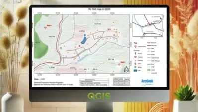
QGIS Base Course/Step by Step/Level1
Caner Bozkurt
1:29:45
Description
Learn how to use QGIS for GIS Tasks
What You'll Learn?
- How to use QGIS 3.30 From the Stratch
- How to add datas
- How to create geodatabase
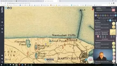
- How to digitize raster sheet
- How to digitize satelite maps
- How to make conversion
- How to create Stratch layers
- How to join datas between two layers
- How to create sql expressions
- How to filter datas
- How to create location queries
- How to calculate data geometries
- How to use geoprocessing tools
- How to use geometry tools
- How to edit geometry
- How to prepare raster datas/Merge/Clip
- How to make raster analysis
Who is this for?
What You Need to Know?
More details
DescriptionHello,
In this course you will learn basic things you need to know to start you and handle your tasks with GIS software by using QGIS tools.
If you are a GIS user or who has been interested in exploring the options for open source GIS, there has never been a better time to start learning.
There are 7 sections and 25 lectures. All of course tutorial datas will be given as freely to you.
In this course you are going to learn:
How to navigate the QGIS interface.
How to add datas/Vectoral and Raster data
How to create database/Whats Geopackage
How to digitize raster and online map
How to style your data.
How to edit GIS data
How to use selections and filtering to control which features you view and modify.
How to work with attributes.
How to make beautiful printed maps.
How to analyze vector and raster data.
How to make data conversions
How to create basic maps
Much more!
This education is a guide for every beginner in spatial analysis, whether you are a student, an administration employee, a data enthusiast or you just want to expand your competences. By the end of this course You can create how to have a project file that You can later show for example to your future employer.
The course is based on free QGIS software in the latest, 3rd version. Thanks to its open source license, QGIS is widely used by many companies, both state-owned and in the private sector. The environment is constantly being developed, updated and regularly translated into many languages. The multitude of available data analysis options makes it one of the most popular GIS programs in the world!
No knowledge of GIS is required to start the course. You only need to spend some time learning, willingness and knowing how to operate the computer. That's all, you'll learn everything else in the course.
The course starts at the beginner level, where we develop the skills learned in this course.
Who this course is for:
- Students
- Anyone who wants to learn open source GIS Software
- Beginner users or who wants to learn QGIS Step by step
Hello,
In this course you will learn basic things you need to know to start you and handle your tasks with GIS software by using QGIS tools.
If you are a GIS user or who has been interested in exploring the options for open source GIS, there has never been a better time to start learning.
There are 7 sections and 25 lectures. All of course tutorial datas will be given as freely to you.
In this course you are going to learn:
How to navigate the QGIS interface.
How to add datas/Vectoral and Raster data
How to create database/Whats Geopackage
How to digitize raster and online map
How to style your data.
How to edit GIS data
How to use selections and filtering to control which features you view and modify.
How to work with attributes.
How to make beautiful printed maps.
How to analyze vector and raster data.
How to make data conversions
How to create basic maps
Much more!
This education is a guide for every beginner in spatial analysis, whether you are a student, an administration employee, a data enthusiast or you just want to expand your competences. By the end of this course You can create how to have a project file that You can later show for example to your future employer.
The course is based on free QGIS software in the latest, 3rd version. Thanks to its open source license, QGIS is widely used by many companies, both state-owned and in the private sector. The environment is constantly being developed, updated and regularly translated into many languages. The multitude of available data analysis options makes it one of the most popular GIS programs in the world!
No knowledge of GIS is required to start the course. You only need to spend some time learning, willingness and knowing how to operate the computer. That's all, you'll learn everything else in the course.
The course starts at the beginner level, where we develop the skills learned in this course.
Who this course is for:
- Students
- Anyone who wants to learn open source GIS Software
- Beginner users or who wants to learn QGIS Step by step
User Reviews
Rating

Caner Bozkurt
Instructor's Courses
Udemy
View courses Udemy- language english
- Training sessions 12
- duration 1:29:45
- Release Date 2023/09/10