QGIS 3
Franz Pucha Cofrep
2:39:04
Description
Discover the potential of GIS and learn from scratch. Experience, feel and uncover everything you can achieve with QGIS!
What You'll Learn?
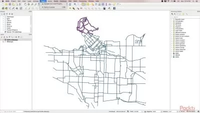
- Create and edit vector layers in QGIS 3, including points, lines, and polygons, and manage their attribute tables efficiently.
- Design professional maps using QGIS 3, applying symbology techniques, labeling, and layout composition skills.
- Use geoprocessing tools like Buffer, Intersect, Clip, and Merge to perform basic spatial analysis in real GIS projects.
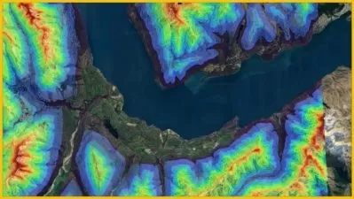
- Perform spatial analysis techniques, including interpolation, slope mapping, and watershed delineation using QGIS 3.
Who is this for?
What You Need to Know?
More details
DescriptionThis QGIS 3 course provides a comprehensive, hands-on approach to learning Geographic Information Systems (GIS). It is designed for beginners with basic knowledge of GIS and geodesy concepts, focusing on practical application rather than extensive theory.
The course curriculum covers essential QGIS functions and GIS operations. We begin with QGIS installation and interface familiarization, then progress through vector data management, including the creation and manipulation of point, line, and polygon layers. Students will learn to perform table operations, field calculations, and data entry.
Map design is a key component, encompassing symbology application, labeling techniques, and the creation of professional layout elements. The course also introduces fundamental geoprocessing tools such as Buffer, Intersect, Clip, and Merge, along with basic spatial analysis techniques including interpolation, slope mapping, and watershed delineation.
Each topic is explored through practical exercises, allowing students to immediately apply their learning to real-world scenarios. By the course's conclusion, participants will have developed practical skills in QGIS 3, preparing them for GIS tasks across various fields.
This course is ideal for those seeking to quickly gain practical QGIS skills through direct, hands-on learning, without extensive theoretical discussions. Our step-by-step approach ensures you'll gain confidence in using QGIS for diverse mapping and spatial analysis tasks.
Who this course is for:
- Beginners in GIS looking to gain practical skills in QGIS 3 without extensive theory.
- Professionals in fields like urban planning, environmental science, or geography seeking to incorporate GIS into their work.
- Students in spatial sciences or related disciplines wanting hands-on experience with a powerful, open-source GIS tool.
This QGIS 3 course provides a comprehensive, hands-on approach to learning Geographic Information Systems (GIS). It is designed for beginners with basic knowledge of GIS and geodesy concepts, focusing on practical application rather than extensive theory.
The course curriculum covers essential QGIS functions and GIS operations. We begin with QGIS installation and interface familiarization, then progress through vector data management, including the creation and manipulation of point, line, and polygon layers. Students will learn to perform table operations, field calculations, and data entry.
Map design is a key component, encompassing symbology application, labeling techniques, and the creation of professional layout elements. The course also introduces fundamental geoprocessing tools such as Buffer, Intersect, Clip, and Merge, along with basic spatial analysis techniques including interpolation, slope mapping, and watershed delineation.
Each topic is explored through practical exercises, allowing students to immediately apply their learning to real-world scenarios. By the course's conclusion, participants will have developed practical skills in QGIS 3, preparing them for GIS tasks across various fields.
This course is ideal for those seeking to quickly gain practical QGIS skills through direct, hands-on learning, without extensive theoretical discussions. Our step-by-step approach ensures you'll gain confidence in using QGIS for diverse mapping and spatial analysis tasks.
Who this course is for:
- Beginners in GIS looking to gain practical skills in QGIS 3 without extensive theory.
- Professionals in fields like urban planning, environmental science, or geography seeking to incorporate GIS into their work.
- Students in spatial sciences or related disciplines wanting hands-on experience with a powerful, open-source GIS tool.
User Reviews
Rating
Franz Pucha Cofrep
Instructor's Courses
Udemy
View courses Udemy- language english
- Training sessions 48
- duration 2:39:04
- Release Date 2025/02/23