Open source GIS & remote sensing for conservation (Beginner)
Josef Clifford,Dr Rajan Amin,Peter Maina
5:59:00
Description
Applied course exploring practical uses of GIS and remote sensing in environment and wildlife conservation.
What You'll Learn?
- GIS
- Remote sensing
- Conservation
- Environmental issues
- QGIS
- Ecological surveys
Who is this for?
What You Need to Know?
More details
DescriptionThis course introduces essential theoretical concepts of GIS before diving straight into practical uses of this incredible tool to support environment and wildlife conservation. It is suitable for students with limited or no knowledge of GIS, as well as those looking to refresh or enhance their skills applied to the field of conservation.
Developed by Josef Clifford, an experienced GIS & remote sensing specialist, the course curriculum and content was developed in collaboration with scientists from the Wildlife Research and Training Institute of Kenya and the Zoological Society of London to ensure the content is rigorous and relevant.
Real ecological survey data from Kenya, Cameroon and other locations has also been provided by these institutions which is used within practical sessions of this course.
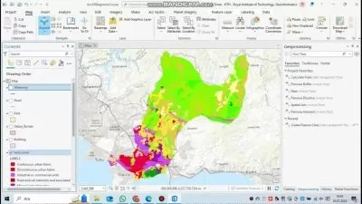
We will cover a multitude of tasks ranging from collecting and managing spatial data during ecological surveys, visualising survey data, and undertaking spatial analysis to understand spatial relationships and extract covariate data. In addition, we will see how to source free spatial data online, how to georeference images, and we will develop publication quality maps. The course will primarily utilise QGIS as well as Google Earth, whilst the advanced course (to be released in late 2024) will also make use of Google Earth Engine and R.
Note that the beginner course focuses more on GIS, whilst the advanced course (to be released in late 2024) will explore remote sensing techniques in greater depth. Good luck and IÂ hope you enjoy the course!
Who this course is for:
- Conservationists
- Ecologists
- Wildlife biologists
- Beginners in GIS and remote sensing
- Professionals in GIS interested in exploring new applications
This course introduces essential theoretical concepts of GIS before diving straight into practical uses of this incredible tool to support environment and wildlife conservation. It is suitable for students with limited or no knowledge of GIS, as well as those looking to refresh or enhance their skills applied to the field of conservation.
Developed by Josef Clifford, an experienced GIS & remote sensing specialist, the course curriculum and content was developed in collaboration with scientists from the Wildlife Research and Training Institute of Kenya and the Zoological Society of London to ensure the content is rigorous and relevant.
Real ecological survey data from Kenya, Cameroon and other locations has also been provided by these institutions which is used within practical sessions of this course.
We will cover a multitude of tasks ranging from collecting and managing spatial data during ecological surveys, visualising survey data, and undertaking spatial analysis to understand spatial relationships and extract covariate data. In addition, we will see how to source free spatial data online, how to georeference images, and we will develop publication quality maps. The course will primarily utilise QGIS as well as Google Earth, whilst the advanced course (to be released in late 2024) will also make use of Google Earth Engine and R.
Note that the beginner course focuses more on GIS, whilst the advanced course (to be released in late 2024) will explore remote sensing techniques in greater depth. Good luck and IÂ hope you enjoy the course!
Who this course is for:
- Conservationists
- Ecologists
- Wildlife biologists
- Beginners in GIS and remote sensing
- Professionals in GIS interested in exploring new applications
User Reviews
Rating

Josef Clifford
Instructor's Courses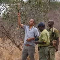
Dr Rajan Amin
Instructor's Courses
Peter Maina
Instructor's Courses
Udemy
View courses Udemy- language english
- Training sessions 60
- duration 5:59:00
- Release Date 2024/03/19