MySQL for Geospatial Applications
Michael Miller
5:38:26
Description
Build your own multi-user enterprise GIS for free
What You'll Learn?
- Understand the advantages of storing spatial information in spatially enabled databases
- Install MySQL locally for development purposes and/or access an instance of MySQL that is running on their organizations intranet, a web host, or the cloud
- Write SQL queries to retrieve and analyze spatial data.
- Use the tools available in MySQL to validate data and control user access
- Perform basic database administration functions to keep your spatial database running smoothly
- Customize your database with your business logic using stored procedures, user defined functions, and triggers
- Access your data from a variety of clients including, QGIS, ArcGIS, PhPMyAdmin, MySQL Workbench, the MySQL command line, Python, and web maps
Who is this for?
More details
DescriptionThis course is intended to provide an introduction to spatial databases in general and MySQL in particular to GIS professionals who are interested in expanding their skillset to multi-user enterprise level spatial databases. MySQL is available on almost all web-hosting platforms and geospatial capabilities have been part of the core MySQL distribution since version 5.6. This means that is far easier and less expensive to setup and deploy a spatial database with MySQL than other options such as PostGIS. At this point it does not have all the bells and whistles that PostGIS has but all of the important core functionality is there. This course uses the latest (as of 11/22) versions of MySQL (8.0, and QGIS (3.28). I believe it is the most current and thorough course on spatial databases available today. You will learn
What a spatial database is and why you would want to use one.
What SQL is, why you would want to use it, and how it can be applied to geospatial concepts.
How to install MySQL locally for development purposes and how to access a production version via a network or the internet.
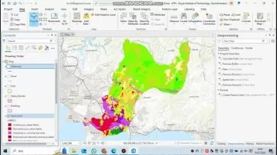
How to load your spatial data into MySQL and access it from a variety of clients, especially QGIS
The basics of SQL for both spatial and non-spatial queries
How to validate data and control user access with the tools built-in to MySQL
Optimizing your queries for the best performance
The basics of programming custom functions with the MySQL stored procedure language
The basics of database administration to keep your database operating smoothly
Deploy your database on a web'hosting service so that it is available to anyone with an internet connection (assuming they have been granted access priveleges)
Who this course is for:
- GIS professionals who are interested in expanding their GIS skillsets into multi-user enterprise level spatial databases.
- GIS professionals who want a simple and inexpensive way to get started with multi-user enterprise level spatial databases.
This course is intended to provide an introduction to spatial databases in general and MySQL in particular to GIS professionals who are interested in expanding their skillset to multi-user enterprise level spatial databases. MySQL is available on almost all web-hosting platforms and geospatial capabilities have been part of the core MySQL distribution since version 5.6. This means that is far easier and less expensive to setup and deploy a spatial database with MySQL than other options such as PostGIS. At this point it does not have all the bells and whistles that PostGIS has but all of the important core functionality is there. This course uses the latest (as of 11/22) versions of MySQL (8.0, and QGIS (3.28). I believe it is the most current and thorough course on spatial databases available today. You will learn
What a spatial database is and why you would want to use one.
What SQL is, why you would want to use it, and how it can be applied to geospatial concepts.
How to install MySQL locally for development purposes and how to access a production version via a network or the internet.
How to load your spatial data into MySQL and access it from a variety of clients, especially QGIS
The basics of SQL for both spatial and non-spatial queries
How to validate data and control user access with the tools built-in to MySQL
Optimizing your queries for the best performance
The basics of programming custom functions with the MySQL stored procedure language
The basics of database administration to keep your database operating smoothly
Deploy your database on a web'hosting service so that it is available to anyone with an internet connection (assuming they have been granted access priveleges)
Who this course is for:
- GIS professionals who are interested in expanding their GIS skillsets into multi-user enterprise level spatial databases.
- GIS professionals who want a simple and inexpensive way to get started with multi-user enterprise level spatial databases.
User Reviews
Rating

Michael Miller
Instructor's Courses
Udemy
View courses Udemy- language english
- Training sessions 29
- duration 5:38:26
- Release Date 2022/12/24