Learning the Esri stack: ArcGIS Pro, Model Builder, Arcpy
Arthur Lembo
4:17:39
Description
a workshop to learn the basics of Esri's new offerings in ArcGIS Pro
What You'll Learn?
- How to define a spatial problem, and plan out the approach for solving it
- You will learn the differences between ArcMap and ArcGIS Pro
- You will get a basic overview of the ArcGIS Pro interface
- How to use ArcGIS Pro to solve our GIS problem
- How to use Model Builder in ArcGIS Pro to solve our GIS problem
- How to use Python within ArcGIS Pro to solve our GIS problem
Who is this for?
What You Need to Know?
More details
DescriptionAs you probably know, Esri is moving their users to the latest software, ArcGIS Pro. Perhaps you are a little hesitant in making that leap. Or, maybe you want to learn how to use different approaches to solve a GIS problem including the GUI, Model Builder, Python scripting, or a 3rd party extension that uses SQL. Or, maybe you want to be able to articulate the strengths and limitations of the different Esri approaches. Whether you are moving to the new Esri platform, of just trying to gain the necessary skills to land that next job in your career, this course will help you get there.
In this course, we are going to explore 4 different ways to solve a GIS problem using Esri software: the ArcGIS Pro graphical user interface (GUI), Model Builder, Python Scripting with Arcpy, and spatial SQL with SQL for ArcGIS Pro. As a bonus, I'm also going to introduce you to some of the cloud based solutions that Esri has available.
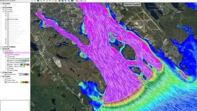
As our base scenario, we are going to perform a GIS analysis to evaluate access to COVID-19 vaccination sites for different ethnic populations in the State of Maryland. Believe it or not, the simple question of what percentage of the population is within a specified distance of a vaccination center is trickier than you'd think, requiring a number of steps to complete.
Fortunately, the tools in Esri's ArcGIS Pro allow us to accomplish this task in many different ways. So, you'll not only learn how to use the different approaches, you'll also have a good understanding of the differences among the solutions. It's one thing to be introduced to the different options, and being able to parrot back the strengths and weaknesses of each approach. But, it's another thing to have the actual hands on experience in doing it.Â
As you follow along with me, using the data I provide you, you'll be able to say I have actually used these tools in ArcGIS Pro, and from experience can tell you the strengths and weaknesses of each approach. In the videos, we'll also discuss the appropriateness of each tool, given the particular problem you may be facing.Â
Who this course is for:
- GIS users wanting to learn how to use ArcGIS Pro, Model Builder, and Arcpy
As you probably know, Esri is moving their users to the latest software, ArcGIS Pro. Perhaps you are a little hesitant in making that leap. Or, maybe you want to learn how to use different approaches to solve a GIS problem including the GUI, Model Builder, Python scripting, or a 3rd party extension that uses SQL. Or, maybe you want to be able to articulate the strengths and limitations of the different Esri approaches. Whether you are moving to the new Esri platform, of just trying to gain the necessary skills to land that next job in your career, this course will help you get there.
In this course, we are going to explore 4 different ways to solve a GIS problem using Esri software: the ArcGIS Pro graphical user interface (GUI), Model Builder, Python Scripting with Arcpy, and spatial SQL with SQL for ArcGIS Pro. As a bonus, I'm also going to introduce you to some of the cloud based solutions that Esri has available.
As our base scenario, we are going to perform a GIS analysis to evaluate access to COVID-19 vaccination sites for different ethnic populations in the State of Maryland. Believe it or not, the simple question of what percentage of the population is within a specified distance of a vaccination center is trickier than you'd think, requiring a number of steps to complete.
Fortunately, the tools in Esri's ArcGIS Pro allow us to accomplish this task in many different ways. So, you'll not only learn how to use the different approaches, you'll also have a good understanding of the differences among the solutions. It's one thing to be introduced to the different options, and being able to parrot back the strengths and weaknesses of each approach. But, it's another thing to have the actual hands on experience in doing it.Â
As you follow along with me, using the data I provide you, you'll be able to say I have actually used these tools in ArcGIS Pro, and from experience can tell you the strengths and weaknesses of each approach. In the videos, we'll also discuss the appropriateness of each tool, given the particular problem you may be facing.Â
Who this course is for:
- GIS users wanting to learn how to use ArcGIS Pro, Model Builder, and Arcpy
User Reviews
Rating

Arthur Lembo
Instructor's Courses
Udemy
View courses Udemy- language english
- Training sessions 21
- duration 4:17:39
- Release Date 2024/04/29