Learn Transport Network Analysis using ArcGIS from scratch
James Awulu
1:05:02
Description
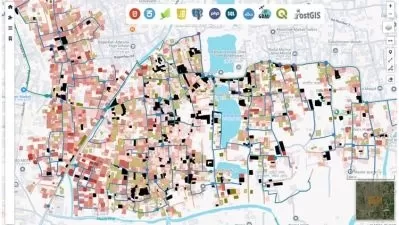
Spatio-Temporal Analysis of Transportation Networks
What You'll Learn?
- Downloading and Georeferencing Raster data from GoogleEarth Pro
- Mosaicking, Clipping and Digitization of Raster data
- Creating and Building a Transport Network Dataset
- Preparing and manipulating Transport Network data attributes
- Perform Closest Facility and Service Area (Isochrone) Network analysis
Who is this for?
More details
DescriptionHello, my name is James Awulu. I am a GIS Analyst and a Transport Engineer enthusiastic in utilizing GIS and spatial analysis in solving problems in multifarious sectors such as Transportation, Agriculture, and Climate. With a vast educational and work experience in Africa and Asia, I am keen on promoting the use of GIS and its applicability.
In this course, I will be teaching you how to learn GIS as a beginner;
• Download Spatial Data from varied sources
• Acquire Data from GoogleEarth Pro
• Convert shapefiles (.SHP) to .KMZ/KML format
• Geocode/Geo-reference Raster data
• Mosaic multiple satellite imageries
• Clip raster data to desired shapefile boundary
• Digitize Raster data to create a Road map
This course will explicitly tutor you on how to carry out Spatial and Temporal Analysis of Transportation networks;
• Dissolve road networks to aid data manipulation
• Estimate length of road networks, assign standard speed of traffic peculiar to the area of interest
• Prepare and manipulate Network attribute data,
• Assign closest Facilities from points of Origins to Points of Interests (Destinations),
• Prepare Isochrone maps
N/B: This course is resourceful for GIS enthusiast in transportation engineering. Beneficial to both Beginners and Experts since it is easily comprehendible to individual with no prior GIS experience.Â
Tutorials are project-based, brief, explicit and comprehendible.
Who this course is for:
- GIS and Transport enthusiast
- GIS beginners
Hello, my name is James Awulu. I am a GIS Analyst and a Transport Engineer enthusiastic in utilizing GIS and spatial analysis in solving problems in multifarious sectors such as Transportation, Agriculture, and Climate. With a vast educational and work experience in Africa and Asia, I am keen on promoting the use of GIS and its applicability.
In this course, I will be teaching you how to learn GIS as a beginner;
• Download Spatial Data from varied sources
• Acquire Data from GoogleEarth Pro
• Convert shapefiles (.SHP) to .KMZ/KML format
• Geocode/Geo-reference Raster data
• Mosaic multiple satellite imageries
• Clip raster data to desired shapefile boundary
• Digitize Raster data to create a Road map
This course will explicitly tutor you on how to carry out Spatial and Temporal Analysis of Transportation networks;
• Dissolve road networks to aid data manipulation
• Estimate length of road networks, assign standard speed of traffic peculiar to the area of interest
• Prepare and manipulate Network attribute data,
• Assign closest Facilities from points of Origins to Points of Interests (Destinations),
• Prepare Isochrone maps
N/B: This course is resourceful for GIS enthusiast in transportation engineering. Beneficial to both Beginners and Experts since it is easily comprehendible to individual with no prior GIS experience.Â
Tutorials are project-based, brief, explicit and comprehendible.
Who this course is for:
- GIS and Transport enthusiast
- GIS beginners
User Reviews
Rating

James Awulu
Instructor's Courses
Udemy
View courses Udemy- language english
- Training sessions 11
- duration 1:05:02
- Release Date 2023/03/09