Learn How to Find Groundwater Potential Zones/GIS/RMS/ArcGIS
Caner Bozkurt
4:38:29
Description
Learn how to find Groundwater Potential Zone Analysis for any of the study area in this world
What You'll Learn?
- Weighted Overlay Analysis
- Reclassification Method
- Remote Sensing Method
- Spatial Analysis Methods
- Learn to the differences between İnfluence and Scale values terms(Weighted Overlay Analysis)
- How to print Final Map
- Learn how to calculate potential zone areas
- NDVI and TWI Analysis
- Learn how to create raw criteria rasters
Who is this for?
What You Need to Know?
More details
DescriptionHello,
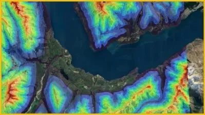
The weights and effects of 11 different layers were calculated for the Groundwater Potential Zone analysis with the Weighted Overlay Analysis method. The use of Geographic Information Systems (GIS) in different type of analysis studies is increasing day by day.
Geographic Information Systems are used to collect, process and analyze existing data in order to identify potential groundwater areas. In this study, groundwater potential areas of the district of Uckerland where its located in Germany The Groundwater analysis was determined by GIS and Remote Sensing techniques.
In the modeling phase, the Weighted Overlay Analysis method was applied and digital maps such as Elevation, Slope, TWI, NDVI,Linemant Density, Precipitation, Land Use and Landcover , distance to stream,Geomorphology and Soil maps were produced.
You will learn from where and how the data to be used in the analysis is downloaded, what geographical processes it goes through and how it is prepared for analysis.
Raster and vector data how to be prepared one by one, projection conversion operations, adding fields and the shortcuts that will speed up your process when converting from raster to vector and from vector to raster will be especially useful for you. Based on this study, it has been prepared as a resource for you to do a similar study about any part of the world. By sharing the data I used throughout the study with you, I allow you to practice.
Who this course is for:
- Surveying Engineers
- Geological Engineers
- Hydrology Engineers
- Land Managers
- Students who related with GIS
Hello,
The weights and effects of 11 different layers were calculated for the Groundwater Potential Zone analysis with the Weighted Overlay Analysis method. The use of Geographic Information Systems (GIS) in different type of analysis studies is increasing day by day.
Geographic Information Systems are used to collect, process and analyze existing data in order to identify potential groundwater areas. In this study, groundwater potential areas of the district of Uckerland where its located in Germany The Groundwater analysis was determined by GIS and Remote Sensing techniques.
In the modeling phase, the Weighted Overlay Analysis method was applied and digital maps such as Elevation, Slope, TWI, NDVI,Linemant Density, Precipitation, Land Use and Landcover , distance to stream,Geomorphology and Soil maps were produced.
You will learn from where and how the data to be used in the analysis is downloaded, what geographical processes it goes through and how it is prepared for analysis.
Raster and vector data how to be prepared one by one, projection conversion operations, adding fields and the shortcuts that will speed up your process when converting from raster to vector and from vector to raster will be especially useful for you. Based on this study, it has been prepared as a resource for you to do a similar study about any part of the world. By sharing the data I used throughout the study with you, I allow you to practice.
Who this course is for:
- Surveying Engineers
- Geological Engineers
- Hydrology Engineers
- Land Managers
- Students who related with GIS
User Reviews
Rating

Caner Bozkurt
Instructor's Courses
Udemy
View courses Udemy- language english
- Training sessions 22
- duration 4:38:29
- Release Date 2024/12/21