GIS & Geospatial Analysis with Python, Geopandas, and Folium
Christ Raharja
4:15:52
Description
Mapping population density, flood risk, snow cover, monitoring air quality index, modelling and optimizing routes
What You'll Learn?
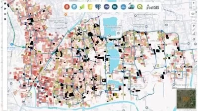
- Learn how to display interactive map and topographic map using Geopandas, Folium, and Ipyleaflet
- Learn how to conduct proximity analysis for finding nearby cities
- Learn how to extract geographic coordinates from map
- Learn how to perform geocoding and reverse geocoding
- Learn how to calculate distance between two locations
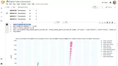
- Learn how to analyze and calculate population density
- Learn how to visualize population density on interactive map
- Learn how to analyze air quality index
- Learn how to monitor air quality in multiple locations
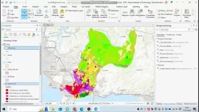
- Learn how to analyze and calculate flood risk
- Learn how to map flood risk on interactive map
- Learn how to analyze snowfall, snow depth, and climate data
- Learn how to map snow cover using Folium
- Learn how to model and optimize route using Open Street Map Network X
- Learn how to model and optimize bus routes using Dijkstra algorithm
- Learn the basic fundamentals of geospatial analysis and its use cases
- Learn geospatial analysis workflow. This section covers data collection, preprocessing, cleaning, exploratory data analysis, spatial analysis, and modeling
- Learn about geospatial data visualization methods like choropleth maps, heatmaps, 3D maps, flow maps, point maps, and cartogram maps
Who is this for?
What You Need to Know?
More details
DescriptionWelcome to GIS & Geospatial Analysis with Python, Geopandas, and Folium course. This is a comprehensive project-based course where you will learn step-by-step on how to perform geospatial analysis techniques specifically leveraging GIS for urban planning. You will build projects like mapping population density, monitoring air quality, mapping flood risks, mapping snow cover, modeling and optimizing routes, and we will be using Python libraries like Pandas, Geopandas, Folium, Geocoder, and Ipyleaflet. The course perfectly combines geospatial analysis with urban planning, providing an ideal opportunity to practice your programming skills while improving your geospatial knowledge. In the introduction session, you will learn the basic fundamentals of geospatial analysis, such as getting to know its use cases, understanding geospatial analysis workflow, learning about technical challenges and limitations in GIS. Then, in the next section, we will learn about geospatial data visualization methods like choropleth maps, heatmaps, 3D maps, flow maps, point maps, and cartogram maps. This section is very critical because it provides you with the necessary tools to communicate your analysis effectively to stakeholders and decision-makers involved in urban planning. Afterward, in the next section, we will download geospatial datasets from Kaggle, the datasets contain valuable information like demographic data, land use data, and climate data. Before starting the project, we will learn about basic geospatial techniques, like importing geospatial data, displaying interactive maps, extracting coordinates from map, calculating distance between two locations, finding nearby cities using proximity analysis, performing geocoding and reverse geocoding. This section is very essential because it provides you with the fundamental skills and knowledge needed to effectively work with geospatial data and prepare you well for the upcoming projects. In the next section, we will start the projects. There will be five projects. In the first project, you will analyze population density to identify densely populated areas and assess their suitability for urban planning initiatives. For the second project, you will focus on monitoring air quality to identify areas with high pollution levels and assess their impact on public health and the environment. In the third project, you will map flood risk areas to facilitate disaster preparedness and mitigation efforts. In the fourth project, you will map snow cover to support transportation planning and finding safer travel routes during winter season. Lastly, in the fifth project, you will develop optimal transportation routes to improve efficiency and reduce travel times for urban commuters.
First of all, before getting into the course, we need to ask ourselves this question: why should we learn about geographic information systems and geospatial analysis? Well, here is my answer: geographic information systems are essential for understanding spatial relationships and patterns in data, enabling us to make informed decisions and solve real-world problems more effectively. These technologies play a crucial role in various industries, for example, urban planning, environmental science, and public health, allowing us to analyze spatial data and derive meaningful insights for better decision-making. Additionally, there are tons of business opportunities, for example, you can develop custom GIS applications like property valuation tools, supply chain optimization platforms, or tourism route planners. These applications leverage location-based insights to drive decision-making and enhance operational efficiency.
Below are things that you can expect to learn from this course:
Learn the basic fundamentals of geospatial analysis and its use cases
Learn geospatial analysis workflow. This section covers data collection, data preprocessing, data cleaning, exploratory data analysis, spatial analysis, and modeling
Learn about geospatial data visualization methods like choropleth maps, heatmaps, 3D maps, flow maps, point maps, and cartogram maps
Learn how to display interactive map and topographic map using Geopandas, Folium, and Ipyleaflet
Learn how to calculate distance between two locations
Learn how to extract geographic coordinates from map
Learn how to perform geocoding and reverse geocoding
Learn how to conduct proximity analysis for finding nearby cities
Learn how to analyze and calculate population density
Learn how to visualize population density on interactive map
Learn how to analyze air quality index
Learn how to monitor air quality in multiple locations
Learn how to analyze and calculate flood risk
Learn how to map flood risk on interactive map
Learn how to analyze snowfall and snow depth in multiple locations
Learn how to map snow cover using Folium
Learn how to model and optimize route using Open Street Map Network X
Learn how to model and optimize bus routes using Dijkstra algorithm
Who this course is for:
- People who are interested in learning about geographic information system and its applications
- People who are interested in leveraging geospatial analysis techniques to enhance urban planning
Welcome to GIS & Geospatial Analysis with Python, Geopandas, and Folium course. This is a comprehensive project-based course where you will learn step-by-step on how to perform geospatial analysis techniques specifically leveraging GIS for urban planning. You will build projects like mapping population density, monitoring air quality, mapping flood risks, mapping snow cover, modeling and optimizing routes, and we will be using Python libraries like Pandas, Geopandas, Folium, Geocoder, and Ipyleaflet. The course perfectly combines geospatial analysis with urban planning, providing an ideal opportunity to practice your programming skills while improving your geospatial knowledge. In the introduction session, you will learn the basic fundamentals of geospatial analysis, such as getting to know its use cases, understanding geospatial analysis workflow, learning about technical challenges and limitations in GIS. Then, in the next section, we will learn about geospatial data visualization methods like choropleth maps, heatmaps, 3D maps, flow maps, point maps, and cartogram maps. This section is very critical because it provides you with the necessary tools to communicate your analysis effectively to stakeholders and decision-makers involved in urban planning. Afterward, in the next section, we will download geospatial datasets from Kaggle, the datasets contain valuable information like demographic data, land use data, and climate data. Before starting the project, we will learn about basic geospatial techniques, like importing geospatial data, displaying interactive maps, extracting coordinates from map, calculating distance between two locations, finding nearby cities using proximity analysis, performing geocoding and reverse geocoding. This section is very essential because it provides you with the fundamental skills and knowledge needed to effectively work with geospatial data and prepare you well for the upcoming projects. In the next section, we will start the projects. There will be five projects. In the first project, you will analyze population density to identify densely populated areas and assess their suitability for urban planning initiatives. For the second project, you will focus on monitoring air quality to identify areas with high pollution levels and assess their impact on public health and the environment. In the third project, you will map flood risk areas to facilitate disaster preparedness and mitigation efforts. In the fourth project, you will map snow cover to support transportation planning and finding safer travel routes during winter season. Lastly, in the fifth project, you will develop optimal transportation routes to improve efficiency and reduce travel times for urban commuters.
First of all, before getting into the course, we need to ask ourselves this question: why should we learn about geographic information systems and geospatial analysis? Well, here is my answer: geographic information systems are essential for understanding spatial relationships and patterns in data, enabling us to make informed decisions and solve real-world problems more effectively. These technologies play a crucial role in various industries, for example, urban planning, environmental science, and public health, allowing us to analyze spatial data and derive meaningful insights for better decision-making. Additionally, there are tons of business opportunities, for example, you can develop custom GIS applications like property valuation tools, supply chain optimization platforms, or tourism route planners. These applications leverage location-based insights to drive decision-making and enhance operational efficiency.
Below are things that you can expect to learn from this course:
Learn the basic fundamentals of geospatial analysis and its use cases
Learn geospatial analysis workflow. This section covers data collection, data preprocessing, data cleaning, exploratory data analysis, spatial analysis, and modeling
Learn about geospatial data visualization methods like choropleth maps, heatmaps, 3D maps, flow maps, point maps, and cartogram maps
Learn how to display interactive map and topographic map using Geopandas, Folium, and Ipyleaflet
Learn how to calculate distance between two locations
Learn how to extract geographic coordinates from map
Learn how to perform geocoding and reverse geocoding
Learn how to conduct proximity analysis for finding nearby cities
Learn how to analyze and calculate population density
Learn how to visualize population density on interactive map
Learn how to analyze air quality index
Learn how to monitor air quality in multiple locations
Learn how to analyze and calculate flood risk
Learn how to map flood risk on interactive map
Learn how to analyze snowfall and snow depth in multiple locations
Learn how to map snow cover using Folium
Learn how to model and optimize route using Open Street Map Network X
Learn how to model and optimize bus routes using Dijkstra algorithm
Who this course is for:
- People who are interested in learning about geographic information system and its applications
- People who are interested in leveraging geospatial analysis techniques to enhance urban planning
User Reviews
Rating

Christ Raharja
Instructor's Courses
Udemy
View courses Udemy- language english
- Training sessions 23
- duration 4:15:52
- Release Date 2024/07/25