GIS and Remote Sensing for Geological Exploration
Prof. Matteo Mirabilio
2:58:43
Description
Apply GIS Tecnlogy and Remote Sensing to geology exploration ( Geothermal - Mineral - Gas )
What You'll Learn?
- What about GIS : cartography projection, type of data
- Short introduction to remote sensing : type of sensor, spettrometry to mineral exploration, Infrared Image to Geothermal Exploration - Pansharped Image
- Using GIS to improve Remote Sensing Data for Geological Regional Pattern - Panshared Image Capture Structure Geology and Geomorphology - Improve
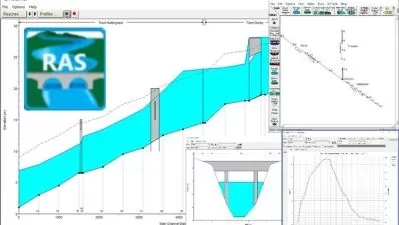
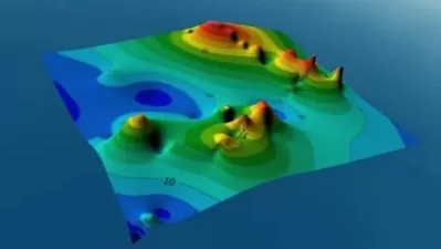
- Manage Drillhole data and combine with remote sensig data for exploration project : evalute 3D Volumetric Reservoir Data.
- Geothermal and Mining Exploration using Landsat and Aster Image
- Passive Sensor - Radar image to monitor Spill Oil
Who is this for?
More details
DescriptionCourse will be helped geology students and Professional Geology in exploration activity for Mineral, Geothermal and Gas purpose. In particular course starting to introduce basic concept of GIS like cartography project , international code EPSG, find Remote Sensing Data ( buy or free download) . Starting to understand Remote Sensing, classify data by geometry and radiometric resolution; using different type of Remote sensing data for different purpose ; Panshared RGB Image for Structural Geology ; Infrared Image for Geothermal exploration ; use SAR Image to monitor area of GAS extraction , deformation and subsidence. Manage this data in GIS software like QGIS and ArcGis ,construction shapefile for delination of structural and geomorplogy pattern. Build digital surface model to extract section and interpolate with drillhole data. Calculate NDVI and other formula to extract potetial Geothermal area Index ; Use other band and radiometric data for extract geological-mineral mapping. Use SAR and calculate diffent DTM for estimate deformation and controll area. Students and Professional will be able to understand and able to manage and use free GIS software like ( QGIS ) and ArcPro to study potential exploration area, they will acquire the most important technique to process Remote sensing data ( classify that) and extract principal geology data; also they will be able to import drillhole data, evaluate 3D reversoir volume and intersect with remote sensing data.
Who this course is for:
- Professional Geologist - Geomatician
- Student and Degree Geology
- Geological Engeneering
- Geophysict
Course will be helped geology students and Professional Geology in exploration activity for Mineral, Geothermal and Gas purpose. In particular course starting to introduce basic concept of GIS like cartography project , international code EPSG, find Remote Sensing Data ( buy or free download) . Starting to understand Remote Sensing, classify data by geometry and radiometric resolution; using different type of Remote sensing data for different purpose ; Panshared RGB Image for Structural Geology ; Infrared Image for Geothermal exploration ; use SAR Image to monitor area of GAS extraction , deformation and subsidence. Manage this data in GIS software like QGIS and ArcGis ,construction shapefile for delination of structural and geomorplogy pattern. Build digital surface model to extract section and interpolate with drillhole data. Calculate NDVI and other formula to extract potetial Geothermal area Index ; Use other band and radiometric data for extract geological-mineral mapping. Use SAR and calculate diffent DTM for estimate deformation and controll area. Students and Professional will be able to understand and able to manage and use free GIS software like ( QGIS ) and ArcPro to study potential exploration area, they will acquire the most important technique to process Remote sensing data ( classify that) and extract principal geology data; also they will be able to import drillhole data, evaluate 3D reversoir volume and intersect with remote sensing data.
Who this course is for:
- Professional Geologist - Geomatician
- Student and Degree Geology
- Geological Engeneering
- Geophysict
User Reviews
Rating

Prof. Matteo Mirabilio
Instructor's Courses
Udemy
View courses Udemy- language english
- Training sessions 10
- duration 2:58:43
- Release Date 2023/02/28