Flutter Google Map APIs Google Cloud Course
Coding Cafe
5:06:14
Description
Learn How to use Google Places & Directions API, Google Reverse GeoCoding & Forward GeoCoding API in Android iOS Apps
What You'll Learn?
- Google Map APIs
- Google Places API
- Google Direction API
- Google Reverse GeoCoding API
- Google Forward GeoCoding API
- Draw Routes Between Different Locations on Map
- Draw Polygons on Google Map
- Display Custom Information Window on Locations Markers
- Show Custom Icons as Markers on Google Map
- and much more
Who is this for?
What You Need to Know?
More details
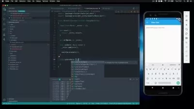
DescriptionIn this course you will learn and implement Google APIs using Flutter.
The Places API is a service that accepts HTTP requests for location data through a variety of methods. It returns formatted location data and imagery about establishments, geographic locations, or prominent points of interest.
Create location-aware features to make detailed location data easily available to your users. The data available through the Places API is built on one of the most accurate, up-to-date, and comprehensive place models of the real world. Here are example use cases for applications:
Display condo rentals within major metropolitan areas with results targeted specifically to cities.
Include place details in a pickup or delivery status update.
Display a list of parks in an area along with user-submitted photos and reviews.
Provide people planning trips with contact information, reviews, and price levels for establishments along the way.
You can use the Places API to include the following features in your applications:
Provide place search results from different types of users queries, such as text input, nearby locations, and ambiguous or categorical user queries.
Enable autocomplete features for different search types, either specific text queries or categorical queries.
Refine the type of details returned about a place, such as operating hours, a summary, user reviews, and a photo.
Add high-quality photos to locations served by your application.
The term geocoding generally refers to translating a human-readable address into a location on a map. The process of doing the opposite, translating a location on the map into a human-readable address, is known as reverse geocoding.
Geocoding is the process of converting addresses (like a street address) into geographic coordinates (like latitude and longitude), which you can use to place markers on a map, or position the map. Reverse geocoding is the process of converting geographic coordinates into a human-readable address.
Who this course is for:
- anyone who wants to learn and implement google map apis
- anyone who wants to learn and work with apis
In this course you will learn and implement Google APIs using Flutter.
The Places API is a service that accepts HTTP requests for location data through a variety of methods. It returns formatted location data and imagery about establishments, geographic locations, or prominent points of interest.
Create location-aware features to make detailed location data easily available to your users. The data available through the Places API is built on one of the most accurate, up-to-date, and comprehensive place models of the real world. Here are example use cases for applications:
Display condo rentals within major metropolitan areas with results targeted specifically to cities.
Include place details in a pickup or delivery status update.
Display a list of parks in an area along with user-submitted photos and reviews.
Provide people planning trips with contact information, reviews, and price levels for establishments along the way.
You can use the Places API to include the following features in your applications:
Provide place search results from different types of users queries, such as text input, nearby locations, and ambiguous or categorical user queries.
Enable autocomplete features for different search types, either specific text queries or categorical queries.
Refine the type of details returned about a place, such as operating hours, a summary, user reviews, and a photo.
Add high-quality photos to locations served by your application.
The term geocoding generally refers to translating a human-readable address into a location on a map. The process of doing the opposite, translating a location on the map into a human-readable address, is known as reverse geocoding.
Geocoding is the process of converting addresses (like a street address) into geographic coordinates (like latitude and longitude), which you can use to place markers on a map, or position the map. Reverse geocoding is the process of converting geographic coordinates into a human-readable address.
Who this course is for:
- anyone who wants to learn and implement google map apis
- anyone who wants to learn and work with apis
User Reviews
Rating

Coding Cafe
Instructor's Courses
Udemy
View courses Udemy- language english
- Training sessions 23
- duration 5:06:14
- Release Date 2023/10/04