Flooding Risk Assessment with Hec-Ras, Hec-HMS, QGIS
7:17:50
Description
Using Open source softwares freely availabe to develop a Methodology to conduct a Flooding Risk Assessment
What You'll Learn?
- Learn to use open source software such as QGIS, HEC-RAS, HEC-HMS for Flooding Risk Assessment project.
- Learn how to develop cartography and Inundation map, and to conduct Flooding Risk Assessment, flood hazard for private land owner
- Identify flood risk and promote informed planning and development practices to help reduce that risk through the Risk Mapping, Assessment
- Learn how to simulate flooding Hazard, surge, wave and Tsunami that can affect coastal communities
- Learn essential tools in Hec-Ras, hec-Hms to delineate watershed, and buld various projects from Scratch
Who is this for?
What You Need to Know?
More details
DescriptionFinding an accessible course and training in Flooding Risk Assessment using open-source software such us Hec-Ras, Hec-Hms, QGIS can be a nightmare? Methodology to perform Flood Risk Assessment in GIS platform are not very developped and the few available training could be very costly.
I believe that Quality Learning and training should be accessicble and affordable to everyone.
Are you looking for a course that that takes you by hand, teaches you all the concepts, and get you started on a real-life project?
As a planner, architect, property investor, or property developer you’ll need to understand the potential risk flooding when designing and developing a new site. You’ll also need to consider how your site may affect potential flooding elsewhere in the community – especially if it sits within a known flood zone.
Clients Before buying a land, must do their due diligence to verify if the property is not located in a flooding area and to verify that this property is safe before buying it and making the purchase decision.
Whether for a residential or commercial site, you will learn how to identify a flooding area by conducting a Flood Risk Assessment (FRA) and identify these risks
You will learn how to produce an Inundation map, show flooding that could result from a hypothetical failure of a dam
you will learn how to produce inundation map resulting from heavy that can be very critical and lead to a serious flooding.
you will learn how to Identify flooding Hazard, surge, wave and Tsunami that can affect coastal communities.
In this course, actual spatial data from Halifax, Nova Scotia will be used to give a practical hands-on experience of working with real life spatial data and understanding what kind of questions spatial data can help us answer.
However, you will be free to use your own data set or to download any area of the earth where you want to apply this methodology you are going to learn
The underlying motivation for the course is to ensure you can put spatial data analysis into practice today. Start analyzing spatial data for your own projects,
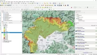
You will learn how to use state of art open-source software freely available online such as QGIS, Hec-Ras, Hec-Hms during this project.
You will develop meticulous methodology from scratch, using Hec-Ras, Hec-Hms. QGIS to build your project.
This course will teach you the basic from scratch to the professional level. The course will take you from zeros to Heroes.
I am Glad you decide to register for this course, Act TODAY! I will personally support you and ensure your experience with this course is a success. Don't hesitate to ask me any question
Who this course is for:
- For undergrade or Grade students who want to improve their skills in Flooding Risk Assessment
- For Professional who want to develop their skills in open source software such-as Hec-Ras, Hec-hms, QGIS and who are involved in GIS mapping
- For everyone who has some interest in Flooding Risk Assessment
Finding an accessible course and training in Flooding Risk Assessment using open-source software such us Hec-Ras, Hec-Hms, QGIS can be a nightmare? Methodology to perform Flood Risk Assessment in GIS platform are not very developped and the few available training could be very costly.
I believe that Quality Learning and training should be accessicble and affordable to everyone.
Are you looking for a course that that takes you by hand, teaches you all the concepts, and get you started on a real-life project?
As a planner, architect, property investor, or property developer you’ll need to understand the potential risk flooding when designing and developing a new site. You’ll also need to consider how your site may affect potential flooding elsewhere in the community – especially if it sits within a known flood zone.
Clients Before buying a land, must do their due diligence to verify if the property is not located in a flooding area and to verify that this property is safe before buying it and making the purchase decision.
Whether for a residential or commercial site, you will learn how to identify a flooding area by conducting a Flood Risk Assessment (FRA) and identify these risks
You will learn how to produce an Inundation map, show flooding that could result from a hypothetical failure of a dam
you will learn how to produce inundation map resulting from heavy that can be very critical and lead to a serious flooding.
you will learn how to Identify flooding Hazard, surge, wave and Tsunami that can affect coastal communities.
In this course, actual spatial data from Halifax, Nova Scotia will be used to give a practical hands-on experience of working with real life spatial data and understanding what kind of questions spatial data can help us answer.
However, you will be free to use your own data set or to download any area of the earth where you want to apply this methodology you are going to learn
The underlying motivation for the course is to ensure you can put spatial data analysis into practice today. Start analyzing spatial data for your own projects,
You will learn how to use state of art open-source software freely available online such as QGIS, Hec-Ras, Hec-Hms during this project.
You will develop meticulous methodology from scratch, using Hec-Ras, Hec-Hms. QGIS to build your project.
This course will teach you the basic from scratch to the professional level. The course will take you from zeros to Heroes.
I am Glad you decide to register for this course, Act TODAY! I will personally support you and ensure your experience with this course is a success. Don't hesitate to ask me any question
Who this course is for:
- For undergrade or Grade students who want to improve their skills in Flooding Risk Assessment
- For Professional who want to develop their skills in open source software such-as Hec-Ras, Hec-hms, QGIS and who are involved in GIS mapping
- For everyone who has some interest in Flooding Risk Assessment
User Reviews
Rating

Udemy
View courses Udemy- language english
- Training sessions 25
- duration 7:17:50
- Release Date 2025/01/23