ESRI ArcGIS Online (AGOL) from zero: 2023 Complete Course
Francisco Molina
2:40:34
Description
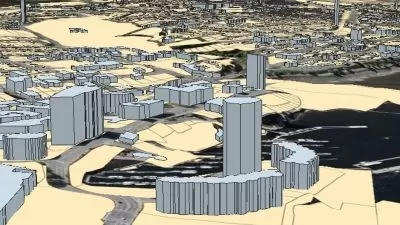
Arcgis Online (AGOL): Creation of online maps, geoportals, and web applications focused on geography in the cloud.
What You'll Learn?
- Do you find the course expensive? Can't you afford it? In the description below, ask me for an exclusive discount for you.
- Develop the ability to analyze and work with geographic information in ArcGIS Online.
- Upload geographic information to the cloud for creating maps, dashboards, and other elements.
- Modify the main aspects of vector symbology to develop web maps.
- Create a web application based on maps created by the user to be able to share geographic content.
Who is this for?
What You Need to Know?
More details
DescriptionArcGIS Online is the GIS tool that will become essential for any user of geographic information systems, since geo-portals and territorial data on the web are on the rise and should be the star product of this decade. Therefore, it is necessary to know its characteristics, how to use it, and how to generate information from it.As an objective, the course proposes to review the different areas that the student must manage within the platform, to create a basic web map and transform it into a viewer or geoportal.
Likewise, the course will develop the skills to use the platform through the practical exercises that the student must complete as they progress through the readings, so that they become familiar with the web environment and the options it offers.
In the course, students will also have the opportunity to learn how to create and edit Story Maps thoroughly. This skill will allow them to present their geographic content efficiently and expressively, which is essential for any mapping project. Through practical exercises and theoretical guidance, students will be able to master the necessary techniques to create attractive and effective Story Maps.
Finally, key concepts will be reviewed so that the student can properly handle the files and formats required by the platform.
At the end of the course, the student will be able to create various accounts, create maps, share content on the web, and most importantly, generate online maps to share on government and private websites, managing the information used to show to clients or counterparts, and thus having a much smoother flow of communication and data.
Who this course is for:
- Geographers, Spatial Analysts, GIS Analysts, Forestry Engineers, Natural Resource Engineers, Environmental Engineers, and Cartographers.
- University and technical GIS students.
- Professionals and technicians focused on territorial information.
As an objective, the course proposes to review the different areas that the student must manage within the platform, to create a basic web map and transform it into a viewer or geoportal.
Likewise, the course will develop the skills to use the platform through the practical exercises that the student must complete as they progress through the readings, so that they become familiar with the web environment and the options it offers.
In the course, students will also have the opportunity to learn how to create and edit Story Maps thoroughly. This skill will allow them to present their geographic content efficiently and expressively, which is essential for any mapping project. Through practical exercises and theoretical guidance, students will be able to master the necessary techniques to create attractive and effective Story Maps.
Finally, key concepts will be reviewed so that the student can properly handle the files and formats required by the platform.
At the end of the course, the student will be able to create various accounts, create maps, share content on the web, and most importantly, generate online maps to share on government and private websites, managing the information used to show to clients or counterparts, and thus having a much smoother flow of communication and data.
Who this course is for:
- Geographers, Spatial Analysts, GIS Analysts, Forestry Engineers, Natural Resource Engineers, Environmental Engineers, and Cartographers.
- University and technical GIS students.
- Professionals and technicians focused on territorial information.
User Reviews
Rating

Francisco Molina
Instructor's Courses
Udemy
View courses Udemy- language english
- Training sessions 34
- duration 2:40:34
- Release Date 2023/06/08