AutoCAD Civil 3d All in One Course using Real Time Project
Naveed Sharafat
4:42:33
Description
AutoCAD Civil 3d Hands on Practice - Basic to Advance Civil 3d Land Development Mega Course
What You'll Learn?
- Navigating the User Interface
- Leveraging a Dynamic Environment
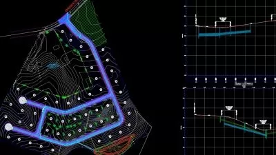
- Establishing Existing Conditions Using Survey Data
- Designing in 2-D using Alignments
- Displaying and Annotating Alignments
- Designing vertically using Profiles
- Displaying and Annotating Profiles
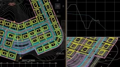
- Designing and Analyzing Boundaries using Parcels
- Displaying and Annotating Parcels
- Designing Gravity Pipe Networks
- Designing Pressure Pipe Networks
- Displaying and Annotating Pipe Networks
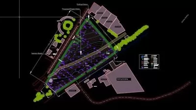
- Designing New terrain - Grading
- Analyzing - Displaying and Annotating Surfaces
Who is this for?
What You Need to Know?
More details
DescriptionWelcome to Mega Course - All in One AutoCAD Civil 3d Course
In this Civil 3d 14 Chapters Course you will get basic to advance knowledge with hands on exercise which will enhance your expertise and you will be able to work as Civil 3d BIM Modeler or Civil 3d designer. You will get Practice drawings for Each Exercise of Civil 3d.
Once you will Complete this Mega Course of AutoCAD Civil 3d, You will be able to do Following Projects:
Topographic Survey data processing
Surface Modelling
Road Design Work including Alignment, Profiles and Assemblies
Subdivision Work using Parcels
Pressure Pipe Network
Gravity Pipe Network
Grading Plans using Civil 3d Grading Creations Tools
Labelling and Annotating Drawings according to City Requirements for Approval
Significant Highlights of The Course:
CHAPTER 1-Navigating the user interface
Navigate the Civil 3d user interface
Launch general commands through the application menu
Launch key software commands and functions using the ribbon
Navigate the design contents using the toolspace
Navigate the model using the drawing area
Communicate with Civil 3d using the command line
Access and modify design information using panorama
Access specialized commands using the transparent Commands toolbar
Get information about your design using the inquiry tool
CHAPTER 2- leveraging a Dynamic Environment
Understand and leverage the connection between objects and styles
Understand the connection between labels and label styles
Understand the connection between objects
Understand the connection between objects and labels
Appreciate the richness of the 3d model
Share data in the dynamic Civil 3d environment
CHAPTER 3: Establishing Existing Conditions using Survey Data
Understand the purpose and function of survey data
Create a survey database
Import survey data
Automate field-to-finish
Edit survey points
Edit survey figures
Create points
CHAPTER 4: Designing in 2-D using Alignments
Understand alignments
Create alignments from objects
Create alignments using the Alignment Creation tools
Edit alignments
Apply design criteria files and check sets
CHAPTER 5: Displaying and Annotating Alignments
Apply alignment styles
Apply alignment labels and label sets
Create station/offset labels
Create segment labels
Apply tag labels and tables
CHAPTER 6: Designing vertically using Profiles
Create surface profiles
Display profiles in profile views
Create design profiles
Edit profiles
Apply design check sets and criteria files
CHAPTER 7: Displaying and Annotating Profiles
Change the display of profiles with profile styles
Configure profile views using profile view styles
Share information through profile view bands
Add detail using profile labels
Work efficiently using profile label sets
Add detail using profile view labels
Project objects to profile views
CHAPTER 8: Designing and Analyzing Boundaries using Parcels
Understand parcels
Create parcels from objects
Create parcels by layout
Edit parcels
CHAPTER 9: Displaying and Annotating Parcels
Apply parcel styles
Apply parcel area labels
Create parcel segment labels
Edit parcel segment labels
Create parcel tables
CHAPTER 10: Designing Gravity Pipe Networks
Understand gravity pipe networks
Create gravity pipe networks
Edit gravity pipe networks
CHAPTER 11: Designing Pressure Pipe Networks
Understand pressure pipe networks
Create pressure pipe networks
Edit pressure pipe networks
CHAPTER 12: Displaying and Annotating Pipe Networks
Display pipe networks using styles
Annotate pipe networks in plan view
Annotate pipe networks in profile view
Create pipe network tables
CHAPTER 13: Designing New terrain - Grading
Understand grading
Understand feature lines
Create feature lines
Edit feature lines
Understand grading objects
Create grading objects
Edit grading objects
CHAPTER 13: Analyzing, Displaying, and Annotating Surfaces
Combine design surfaces
Analyze design surfaces
Calculate earthwork volumes
Label design surfaces
Who this course is for:
Anyone wishing to learn AutoCAD Civil 3D for Grading and Subdivision work
Engineering Students who want to Learn Road Design Using Civil 3d
Land Surveying students and Field Surveyor who want to Process Surveying data
Civil Engineers and Quantity Surveyor
Thanks & Regards
Who this course is for:
- Any Level - But if you Know AutoCAD already then its very easy to ride on this Course.
Welcome to Mega Course - All in One AutoCAD Civil 3d Course
In this Civil 3d 14 Chapters Course you will get basic to advance knowledge with hands on exercise which will enhance your expertise and you will be able to work as Civil 3d BIM Modeler or Civil 3d designer. You will get Practice drawings for Each Exercise of Civil 3d.
Once you will Complete this Mega Course of AutoCAD Civil 3d, You will be able to do Following Projects:
Topographic Survey data processing
Surface Modelling
Road Design Work including Alignment, Profiles and Assemblies
Subdivision Work using Parcels
Pressure Pipe Network
Gravity Pipe Network
Grading Plans using Civil 3d Grading Creations Tools
Labelling and Annotating Drawings according to City Requirements for Approval
Significant Highlights of The Course:
CHAPTER 1-Navigating the user interface
Navigate the Civil 3d user interface
Launch general commands through the application menu
Launch key software commands and functions using the ribbon
Navigate the design contents using the toolspace
Navigate the model using the drawing area
Communicate with Civil 3d using the command line
Access and modify design information using panorama
Access specialized commands using the transparent Commands toolbar
Get information about your design using the inquiry tool
CHAPTER 2- leveraging a Dynamic Environment
Understand and leverage the connection between objects and styles
Understand the connection between labels and label styles
Understand the connection between objects
Understand the connection between objects and labels
Appreciate the richness of the 3d model
Share data in the dynamic Civil 3d environment
CHAPTER 3: Establishing Existing Conditions using Survey Data
Understand the purpose and function of survey data
Create a survey database
Import survey data
Automate field-to-finish
Edit survey points
Edit survey figures
Create points
CHAPTER 4: Designing in 2-D using Alignments
Understand alignments
Create alignments from objects
Create alignments using the Alignment Creation tools
Edit alignments
Apply design criteria files and check sets
CHAPTER 5: Displaying and Annotating Alignments
Apply alignment styles
Apply alignment labels and label sets
Create station/offset labels
Create segment labels
Apply tag labels and tables
CHAPTER 6: Designing vertically using Profiles
Create surface profiles
Display profiles in profile views
Create design profiles
Edit profiles
Apply design check sets and criteria files
CHAPTER 7: Displaying and Annotating Profiles
Change the display of profiles with profile styles
Configure profile views using profile view styles
Share information through profile view bands
Add detail using profile labels
Work efficiently using profile label sets
Add detail using profile view labels
Project objects to profile views
CHAPTER 8: Designing and Analyzing Boundaries using Parcels
Understand parcels
Create parcels from objects
Create parcels by layout
Edit parcels
CHAPTER 9: Displaying and Annotating Parcels
Apply parcel styles
Apply parcel area labels
Create parcel segment labels
Edit parcel segment labels
Create parcel tables
CHAPTER 10: Designing Gravity Pipe Networks
Understand gravity pipe networks
Create gravity pipe networks
Edit gravity pipe networks
CHAPTER 11: Designing Pressure Pipe Networks
Understand pressure pipe networks
Create pressure pipe networks
Edit pressure pipe networks
CHAPTER 12: Displaying and Annotating Pipe Networks
Display pipe networks using styles
Annotate pipe networks in plan view
Annotate pipe networks in profile view
Create pipe network tables
CHAPTER 13: Designing New terrain - Grading
Understand grading
Understand feature lines
Create feature lines
Edit feature lines
Understand grading objects
Create grading objects
Edit grading objects
CHAPTER 13: Analyzing, Displaying, and Annotating Surfaces
Combine design surfaces
Analyze design surfaces
Calculate earthwork volumes
Label design surfaces
Who this course is for:
Anyone wishing to learn AutoCAD Civil 3D for Grading and Subdivision work
Engineering Students who want to Learn Road Design Using Civil 3d
Land Surveying students and Field Surveyor who want to Process Surveying data
Civil Engineers and Quantity Surveyor
Thanks & Regards
Who this course is for:
- Any Level - But if you Know AutoCAD already then its very easy to ride on this Course.
User Reviews
Rating

Naveed Sharafat
Instructor's Courses
Udemy
View courses Udemy- language english
- Training sessions 42
- duration 4:42:33
- Release Date 2024/01/03